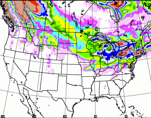
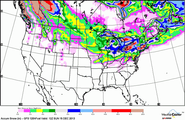
Thanks to the fine gentlemen of Open Snow, who keep us posted on all things weather, we’re bringing you a wrap-up of what this week is expected to look like, from New England through the Pacific Northwest, and everywhere in-between. See where the temps are dropping and (fingers crossed!) the powder is piling up…
The Pacific Northwest
It’s looking to be a snowy week up in Washington, with the Stevens Pass area gathering about an inch a day Wednesday and Thursday, a solid 3-5 inches Thursday night, and another 1-3 inches on Friday. The Summit at Snoqualmie has a more lackluster week to look forward to, with about an inch forecasted for Wednesday, breaking up what is otherwise a rainy couple of days. Crystal Mountain is expected to receive anywhere from 1 to 3 inches per day starting Wednesday night, with temps in the upper 20s and low 30s.
Mt. Baker tops the group, with Thursday night predicted to bring in 4-8 inches, followed by an additional 3-7 on Thursday night. As far as this week is concerned though, Saturday is the golden day for Mt. Baker, with 5-9 inches of fresh expected to fall. British Columbia is having a predictably snowy December, and the Coastal Mountains and the Canadian Rockies will likely have the deepest powder this week. Overall, it will be a mellow week across the region, with comfortable temps and a little snowfall here and there.
For more on what’s happening in the pacific northwest, click here.
The Northern Rockies
Looking towards Wyoming & Montana, the snowfall will be minimal this week, with 1-3 inches predicted to fall tonight at various resorts across the state, with an additional inch or two coming in early this weekend.
Find daily snow reports across this region, right here.
Colorado
After a bitter week of sub-zero temps and blowing snow storms, Colorado will see a warmer week. Snow showers are expected along I-70 on Tuesday night and again through the weekend, but they won’t be leaving much behind in the way of powder. The thermometer will be rising up into the teens and 20s, a nice relief from the numbing cold the state has been enduring. Weather models show a dryer week, with snow in short supply until around the 19th, when patterns are expected to shift, bringing cooler, stormier conditions. For now, get out and enjoy the sunshine and all the fresh snow last week dropped off!
Click here for more info on Colorado weather, courtesy of Joel Gratz.
Utah
After a powder-fueled weekend (around 20 inches of fresh!) Utah can expect a more mellow week, with varied temps — anywhere from 2 – 20 degrees depending on the day! — but no snow predicted for Brighton, Park City, Snowbird, Canyons or Snowbasin.
Want to know more about what’s happening in Utah? Evan Thayer has got your back.
The Sierras
It’s shaping up to be a quiet week in the Tahoe area, with temps warming up into the 30s and 40s through the next 9 or so days. Next week brings the chance for more snow, but for now, all calm in The Sierras!
For more info on this area, check out the Tahoe Daily Snow, with Bryan Allegretto
The Northeast
Snow is falling in the Northeast! The region will see snowfall through early Wednesday, though the heaviest snow will be hitting along the MA coast, where resorts are few and far between, those seated further north can still expect to see about 1-3 inches early on this week. This week is rounding out to be dryer than last week, though Wednesday night and early next weekend could see a little action. Resorts throughout VT and NY are sitting pretty according to Open Snow’s 5-day powder forecast, with Mt. Snow, Killington and Stratton all expecting up to 14 inches, while Kissing Ridge and Snow Ridge, NY are predicted to receive a hefty 30 and 35 inches, respectively. Unlike Colorado, where temps are warming, the northeast is going to be stuck with some chilly numbers, with highs only reaching into the teens. This is great news for snowmaking, however, as these low temps will provide prime conditions for resorts to continue building up their bases.
Looking forward, potential storms are a-brewin’ for early next week; we’ll keep you posted on how they pan out…
Click here to find all things Northeast…
The Midwest
After accumulating just about an inch of snow after last week’s storms, the Twin Cities area is experience a lasting, bitter cold, and very icy conditions. Temps throughout this week are looking to be well below average, with a frigid wind chill. Tonight is expected to bring in an additional inch, with a chance of snow flurries and light accumulation throughout the rest of the week.
Need more? The Upper Midwest Daily Snow with Andrew Murray will get you dialed.
Want to get powder updates delivered to your inbox every week? Sign up for our Powder Alert newsletter
